Gloucester - Dorrigo
14 June 2014
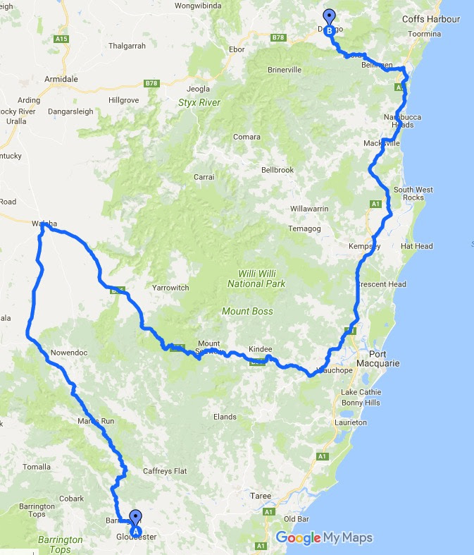
Master Map
Pterodactyl had been insistent that I ride the Oxley Highway on the way home. I didn’t want to because it was a longer way home and meant I’d have to spend an extra night on the road. My research on Day 9 had shown me a couple of alternatives, but I also looked at the Motorcycle Paradise Blog (written by Iron Chef, a former CB1100 owner — indeed I think he may have owned the bike that Pipemasters used in its video of its 4 into 4). The Iron Chef has a great section on good motorcycle rides in Australia and I read the post about the Oxley Highway with interest. He claims — and who am I to argue — that there are more 30-40 km corners than the Tail of the Dragon in the USA and rates it as one of the three best rides in Australia. I’ve included a link to his post on it and it’s worth a read, if only for the photos.
In the end, I decided I’d have to do it, even if not the best way, which is said to be east to west; or up rather than down.
So I left Gloucester to head to Walcha up Thunderbolt’s Way — the route of another nineteenth century bushranger. Thunderbolt’s Way actually runs pretty much all the way to Goondiwindi on the NSW/Queensland border where I’d refuelled on the way to meet the Pterodactyl way back on Day 1, but I was turning off long before that.
It was raining, the only day on which it did, so I was wrapped up in wet weather gear with no possibility of photos on the move. The road out of Gloucester is fantastic. It winds through gorges and ravines climbing and descending and then climbing again before opening out a little into plantation forest and then on to a semi-alpine plain across which you climb to get to Walcha. Once into the forest, the road is mostly good and its a fast ride, even on a cold, wet day. There are some pictures of the higher part here on the Motorcycle Paradise blog. I have one photo of my own from an earlier trip along this road.

The Little Manning River crossing on an earlier trip
I refuelled at Walcha at a very old fashioned service station that offered little in the way of service and certainly had nothing at all resembling coffee. I had no desire to get dressed and then undressed again in the space of a few minutes so I pressed on along the Oxley Highway.
As an aside, it was somewhere around here that I decided that serious long distance riding in the cold and wet would require either the insertion of a catheter or wearing a wetsuit; the palaver of taking off several layers of clothing every time a toilet stop is necessary started to get to me.
As the Iron Chef records, you wonder what the fuss is about as you race east for nearly 60 kms across the alpine plain. I like that sort of clear alpine country, and the road is made for fast travelling. In spite of the damp, I made good time. It has either always been cleared or deforested for farming land. Then you come to the trees and the road starts to descend into corners that get progressively tighter. It’s a stunning road: not just for riding, but because I also really enjoy that sort of winding road through the Australian bush.
About 30 kms after the road begins its descent, you reach the Gingers Creek Café, where I decided to stop for a well-earned coffee. It was still wet, although the rain never got really hard all day, and I was a bit cold. I met a couple of other riders who were on their way up the road. A Kawasaki Ninja 1000 and a black Ducati

I also managed some photos of the road as it approaches Gingers Creek. Only a motorcycle tragic would understand.


And, later, some others a bit further down the hill as the road begins to fall below the tree line.


Even after the quick run across Long Flat at the bottom of the hill there are occasional twisty bits to keep the rider on his or her toes. I can see why the ride from east to west might be better — there’s much to be said for uphill rides — and I’ll be going back to do it some day.
After refuelling at Wauchope, I turned northwards to join the national highway for a while on my way to Dorrigo. Somewhere between Wauchope and Pembroke I heard a noise as if something had fallen off. I stopped and looked, but couldn’t see anything and so kept going.
The ride up the Waterfall Way from the National Highway to Dorrigo has some very enjoyable twisties, particularly between Bellingen and Dorrigo where the road clings to the side of cliff down which the waterfalls which give the road its name tumble.
It had stopped raining when I arrived, but I had worn the full wet weather kit all day. An OK pizza for dinner then bed.
